 Maine Genealogy

This is the fourth in a series of posts I am writing in celebration of the bicentennial of my hometown of Greenwood in Oxford County, incorporated February 2, 1816.
Greenwood began as Township Number Four — fourth in a line of five townships laid out by surveyor Samuel Titcomb between November 1787 and April 1788. Constrained by the boundaries of existing settlements to the north and south (including those that would become Bethel, Norway and Paris), Titcomb divided the unappropriated Commonwealth land between into townships each measuring roughly six miles square, with lines as straight as prior surveys and the landscape would allow.
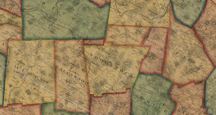
To the east of Number Four lay townships numbered One (later Peru), Two (Franklin and Milton Plantations) and Three (Woodstock).1 To the west lay Township Number Five (later Albany). Titcomb's outline of Number Four has survived fairly intact despite numerous efforts to annex pieces to its neighbors — and one ambitious campaign to create a whole new town.
Early Grievances
The township that would become Greenwood was first organized as Plantation Number Four in 1813. Incorporation lay just three years in the future, but some living at the southern edge of the plantation were impatient. A petition to the General Court in Boston in January 1814 asked that those lots nearest Norway be annexed to that town.
We the subscribers, your humble petitioners, believing that the Legislature at all times are willing to remove inconveniences and redress grievances when known to exist in any part of this Commonwealth, beg leave to represent that they are owners and settlers of lands known by the name of Moshers and Haskells grant, and the five following lots of land lying in township No. 4, viz lots number thirteen and fourteen in the eighth range of lots, and number thirteen and fourteen in the ninth range and number fourteen in the tenth range of lots in said township No. 4, adjoining Norway on the north in the county of Oxford, are so situated that it is and ever will be attended with insurmountable difficulties to be annexed to any town but that of Norway—We therefore pray that the said grant and the said five lots of land may be annexed to the said town of Norway, that the inhabitants on said land may enjoy town privileges in said Norway of which they are now deprived—and is in duty bound will ever pray.2

At a meeting at the schoolhouse on Patch Mountain on April 16, 1814, Noah Tobey, Simeon Sanborn and Duston Patch were appointed a committee to "act (in behalf of the Plantation) against Moshers grant being set off to Norway." Their efforts were successful, but soon trouble arose at the other end of the plantation.
On January 11, 1815, brothers Samuel and Jesse Cross—first settlers of what was later called the Irish Neighborhood — requested that the Commonwealth of Massachusetts set their estates off to Bethel, arguing that they could not "conveniently associate [with] the inhabitants of the said Plantation, in their civil and religious concerns, owing to their local situation, being situated on the northwesterly corner of said Plantation."3 Their petition was denied, but eight years later Samuel would try again — this time in league with Eleazer Twitchell Jr., who had purchased the land of his brother-in-law Jesse Cross in 1819.4
To the Honorable Senate and House of Representatives in Legislature assembled on the first Wednesday of January 1823—
The subscribers, inhabitants of the town of Greenwood in the County of Oxford, beg leave to represent, that their farms and lands are situated in the first and second ranges of lots in the north end of said Greenwood and adjoining Bethel—that they live at a great distance from any inhabitants in Greenwood and near to there in Bethel—that in consequence of their being thus situated, they are almost entirely precluded from enjoying any advantages or privileges of the town-schools or public worship—that they suffer great and serious evils and inconveniences in performing military duty and attending the meetings holden for the purpose of transacting the business of the town, being obliged to travel the distance of eight miles or more to attend company trainings and town meetings and twenty one miles to appear at the regimental musters—and that there is no prospect of their ever being releived from these grievances, should their connexion with said Greenwood continue—Wherefore in order to ameliorate their situation, your petitioners would request the Honorable Legislature to set off the said first and second ranges of lots, together with the inhabitants thereon from said Greenwood and annex them to the town of Bethel. And as in duty bound will ever pray.
Samuel Cross Eleazer Twitchell

Accompanying this petition was another, written in the same hand and similar language, submitted by residents of Greenwood and Bethel.5 The petitions were referred by the House to the Joint Standing Committee on Incorporation of Towns on January 4, 1823, the Senate concurring two days later.
The question of annexation was raised at town meetings in both Greenwood and Bethel, with both towns voting against. In Greenwood, on November 27, Isaac Flint and Paul Wentworth were chosen a committee "to remonstrate Against the petition of Eleazer Twichel and others in Seting of two teir of lots from the North end of said town to Be annexed to Bethel." Timothy Carter, Barbour Bartlett and Phineas Frost, appointed December 29, served as a committee from Bethel for the same purpose. The remonstrances were referred to the Joint Standing Committee on January 9, 1824, read and concurred by the Senate four days later. Greenwood's objections were threefold:
First we consider the town of Greenwood not too large for publick convenience and the families now living on said land are four two of whoom have not expressed a wish to discontinue their connection with the town of Greenwood to form a new one with Bethel as they are as well accommodated now as they can be in Bethel respecting town priviledges.
Secondly the town is verry rough and montaneous and large proportion of the land is unfit for cultivation which requires a greater teritory for the convenience of a town than where the land is more level and fertile.
Thirdly at a legal meeting of the inhabitants of the town the voice of the town was taken on the subject which was almost una[ni]mous to remonstrate against the seperation.
Bethel had three objections as well:
First, we think the said town of Bethel is quite large enough in territory for conveneince to the Inhabitants — Secondly that annexing more lands to said Bethel, it will inlarge its territory without increasing its accommodations; or adding to its Interest — Third it will have a tendency to interrup the present establishment of the School Districts & the centre of the said town of Bethel, and thereby produce much disorder in said town, as well as increase their expenses in making new roads, and expose them to other expenses common to such new tracts of Country.
The matter was referred in February 1824 to the next legislature; the petitions were withdrawn in January 1825. Had the annexation gone forward, Greenwood would have lost the benefit of its finest mill privilege and the location of its future railroad depot.
From Fifield's Mills to Greenwood City
The first town meeting in Greenwood was held in 1816 at the Patch Mountain schoolhouse, on the county road that entered from Norway and ran northward to Bethel. Two years later, town roads were laid out from this county road east to O. Israel B. Fifield's mills at the outlet of Hicks Pond, and from the mills south to Norway line. In 1820 the county laid out a new road from Norway to Bethel past the mills. A schoolhouse was erected south of the bridge in 1822, and it was there that most town meetings would be held for years to come.6 Fifield sold out in 1824, and in 1827 a postal route through town was described as running "by Greenwood Mills." Before long the tiny village would take on a different name — one that reflected both its local reputation and its aspirations: Greenwood City.
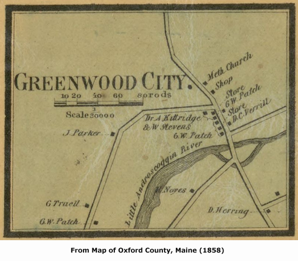
The northern part of Greenwood being still sparsely settled, there was good reason to locate the center of town government at the foot of Hicks Pond. Addison E. Verrill recalled that the village in his youth had "two stores, two taverns with large stables, etc., about six dwelling houses, besides about ten nearby farm houses, a saw mill, in ruins after about 1849, a grist mill, a shingle mill, a school house and a church."7 For Dr. Osgood N. Bradbury, Greenwood City in the 1840s was "a place of importance."
It was stirring and full of activity. It got its name up in all the country round about. The guide boards in all directions pointed that way, and informed the traveler how many miles thither. Parties were often made up in Norway village, as well as in other places, to visit Greenwood City and perhaps dance the night out in its pleasant hostelry. Its schools flourished, its preachers were eloquent, its merchants did a thriving business and the gossips were as busy as in other cities of its size. It was the village of Greenwood. There the dear people came together once a year, made the necessary laws and regulations for the government of the town, and drank their Medford rum in peace. It was directly on the great highway from northern New Hampshire, through Bethel and Gray Corner to Portland.8
This agrees with the assessment of Dr. Nathaniel T. True of Bethel, who advised in 1869 that "If you want to know where Greenwood City is, or rather where it once was, ask anybody who traveled up to the northern part of Oxford County by stage-coach 25 years ago, and he will tell you all about it with livelier recollections than about any other place this side of New York."9
Locke's Mills and the Watertown Petition
As Greenwood City was experiencing its heyday, the settlement at Locke's Mills was itself thriving. After alterations made to its northern end in 1824 and 1843, the same county road that ran through Greenwood City brought traffic to the town's other village. A post office was established in Locke's Mills in July 1840 and—as described in a previous post — the years following saw new industry and increased population. Inevitably, this led to dissatisfaction with the village's distance from the town center. It was agreed in 1845 to post warrants for town meetings both in Locke's Mills and at the tavern in Greenwood City, but the meetings would still be held in the southern part of town.
In 1846 a petition was sent to Augusta, signed by many of the male citizens of Locke's Mills and Howe Hill, as well as a good number of residents of Hamlin's Gore and, in lesser numbers, East Bethel.10
To the Honorable Senate & House of Representatives in Legislature assembled, on the Second Wednesday of May A. D. 1846. The undersigned inhabitants of Bethel, Greenwood & Hamblin's Grant, in the County of Oxford, would humbly represent, that was there a new town incorporated Composed of the east Parish of Bethel, Hamblin's Grant & three tiers of ranges of lots from the North end of Greenwood, it would better Convene the inhabitants living on the above mentioned teritory than what they now are as the towns of Bethel & Greenwood are large in extent & Subject many of your petitioners to travel a great distance to attend Town Meetings. This teritory Seems designed by Nature to become a town As lying within certain ranges of Mountains which Marks its boundary, in the Center are large Ponds Which make a good water privilege on which there is in opperatian a wooling factory a Saw & Grist Mills Mechanic Shops and Store. The flatering prospects which this place now presents leads your pet[it]ioners to believe that it will shortly become a large vilage, it being Situated on the great thoroughfare from the Northerly parts of Newhampshire & Vermont and the contemplated rail road will probably pass through the center.
Hamblin's Grant is now under plantation government hence the State will not be Subject to any addition[al] expense for pa[u]pers were a new town incorporated.
Wherefore you pet[it]ioners pray your honorable body to incorporate the above named place into a New town by the name of Watertown as in duty bound will ever pray.
Samuel B. Locke
Samuel H. Houghton
Silvanus Bartlett
John G. Annes
Samuel Edgerly
Horace Edgerly
Daniel H. Crockett
Alvah Hobbs
Moses C. Hamblen
John G. Burns
Tompson Howe
Stephen D Yeats
Ebenezer Bartlett
David W. Davis
James Yeats
Walter B. Drew
Moses Houghton Jr
A L Cole
Cyrus Swift
Charles Crooker
Harford Paine
Peter Kimball
Isaac W Grant
Phineas Howard
Wm O Pearson
Abraham Jorden
Evi Kneedham
Jacob Kimball
David A Godwin
Joseph Cummings
Samuel Bird
Abijah Bartlett
Emery Swan
John G. Elliot
Hezekiah Moody
Richarard H. Jorden
John Lapham
Thomas Goss
Robet Tyler
Consider Fuller
Caleb Besse Jr
Benjamin Bartlett
John Buck
William M R Lunt
Jonathan Kimball
Peeter Brooks
Peteer Kimball
Josiah Moody
Elbridge Fifield
Jared Young
B. B. Crockett
Wm M Barton
Stephen Hodsdon
Benja Stevens
Amos Andrews
James Lapham
Daniel R Bryant
James A S Bartlett
Artemus Felt
Ira Howe
Stephen Estes
Daniel Edgerly
The act to incorporate Bethel had divided that town into "two distinct parishes," the dividing line to run "between the sixteenth & seventeenth ranges of Lots." Reference to the original plan of Bethel shows that the East Parish encompassed much of Middle Intervale as well as Bean's Corner (East Bethel) and Walker's Mills (South Bethel). The petition asked that the parish with its inhabitants be severed from Bethel and drawn into "Watertown"—a new town whose primary village would be Locke's Mills. Unsurprisingly, this audacious plan was most popular in Bethel among those living closest to Locke's Mills, in the vicinity of Bird Hill. Town meetings in Bethel were in 1846 still held at Middle Intervale, so those living closer to the Androscoggin River had little reason to support secession on these terms.
Hamlin's Gore (often mistakenly called, even in official documents, "Hamlin's Grant") was a piece of land wedged between Woodstock, Bethel and Greenwood northeast of Locke's Mills. It had been left out of Woodstock when that town was incorporated due to an earlier surveyor's error, and was purchased by Dr. Cyrus Hamlin in 1816. The Gore was organized as a plantation in 1826, and would have an independent existence until 1873 when annexed to Woodstock. In his History of Woodstock, Dr. Lapham tells us that "In 1847, there was a project started by Phineas Frost and others, of Bethel, for the incorporation of a new town, made up of the east part of Bethel, Milton plantation and the Gore. The plan found much favor in Bethel, but was stoutly resisted by the Gore and defeated."11 No such resistance was mounted to the Watertown petition of 1846. Just thirteen men of voting age lived on Hamlin's Gore in 1845, and well over two-thirds that number signed the petition.12 The proximity of Locke's Mills to the Gore undoubtedly made Watertown a more attractive prospect than the new town imagined by Phineas Frost—a man described by Lapham as "ever the leader and champion" of the lower (east) parish of Bethel.13
The Watertown petition was referred by the House to the Committee on Incorporation of Towns on May 28, and a day later was referred, in concurrence, by the Senate. Nevertheless, the following week, on June 4, the Senate reconsidered its former vote, and referred the petition to the Committee on Division of Towns, sending it down again for concurrence.
A special town meeting was held in Greenwood on Saturday, June 6, and Josiah Small was chosen agent for the town, charged with presenting the town's remonstrance in Augusta. By Monday, Cyprian Cole, Frederick Coburn and George W. Verrill had ably drafted the document, which detailed the town’s precarious financial state:
Your Remonstrants would respectfully represent that if the prayer of said Petition be granted it will operate to the serious injury of sd Town & to the general disadvantage of the Citizens thereof in many & in several ways, some of which we will specicify [sic] to your Honorable Body—— Firstly we would call the attention of your Honorable Body to the fact that as a Town we are Proverbially poor, & that our inhabitants are generally poor,—We pay, and have paid, for years past to the full amount of from 9 to 10 per cent, in Money & Highway Taxes, on the Amount of our Valuation, with which onerous amount we have not been able to keep from debt, or our Roads from indictment—— Secondly— We would represent,—That there are within the limits of said Town, to the amount of almost Three & a half Thousand Acres of Land, upon which no Tax can be assessed—the same belonging to an unincorporated Literary Institution, to wit "Phillip's Academy"—— Thirdly—We would Represent that there is a large amount of Waste & Unimproveable Land, the amount standing on our Valuation Books at 3875 Acres—the whole number of acres within our exterior limits being 24000 acres, which gives a waste of almost one sixth part, which added to the amount belonging to "Phillips Academy" makes almost One third, upon which we can assess no tax, & through which we have still to make & maintain Roads—— We would further represent—that the amount of Lands contained within the aforesaid Three Ranges is at least 3600 acres free from Waste & Water, & that said land as a general thing is the best in the Town for Agriculture & Farming, & for General privileges & Making Roads—, that a thriving Village is fast building up—, that a Woollen Factory, and valuable Saw & Grist Mill are in successful operation, and that the Polls & Rateable Estates on said Three Ranges, pay to the amount of between one fifth & one fourth of the amount of Taxes assessed on the Polls & Estates in said Town, and we would likewise say, that none of the Land Exempted from Taxation is within the said Three Ranges——And We in conclusion would represent, that the granting the prayer of said Petition, will operate in many other ways to our serious injury & disadvantage, & We, again, respectfully Remonstrate against the same, & pray, that the prayer thereof may not be granted.
This plea for the preservation of the town was referred to the Committee on Division of Towns, was sent up for concurrence, and on June 11 received the Senate's approbation. In less than a month, the movement to separate Locke's Mills from Greenwood had been quashed.
The Town House
Perhaps as a concession to the Watertown petitioners, a motion was put forward September 13, 1847, "to see if the Town will agree to hold one half or one third of the Town Meetings at Locks Mills." The motion carried to hold one-third of the meetings there. (The first meeting in the north part of town would be held at Locke’s grist mill a year later.) A second motion asked that the town "agree to build a Town House." This motion also carried.14
On October 2, 1847, it was stipulated that "Said Town House Shall be thirty by thirty six feet on the Ground and ten foot posted, to be finished in the Same manner as Norway Town House, to [be] well under pinned with Common stone, to be finished by the first day of September next."15 Construction of the house was put up for bid, and was struck off to Simon Furlong for the sum of $300. The house was to be located "as near the centre as convenient between Norway Line and Bethel Line on the New County Road."
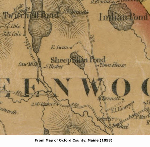
The building site settled upon is one that few current Greenwood residents have had occasion to visit or pass. The "New County Road" was first laid out over Felt's Hill (now Rowe Hill), but in 1837 its route had been adjusted to run along the east shore of Twitchell Pond, below its famous ledge. Stand at the intersection of the Greenwood and Martin Roads looking northward and you will see where the discontinued county road headed toward Rowe Hill. The stretch of road between this point and the foot of the hill was never overcrowded with dwellings. Beyond the turn to William Bennett's well-sited homestead the road passed between hills too steep to farm before skirting the edge of Sheepskin Bog. On early maps this is called a pond, but only when beavers are allowed to carry out their work is it much more than a bog. The region is home to frogs, itinerant waterfowl and the occasional moose, and once was home to Greenwood's town house.
Construction was complete and accepted by town voters on June 3, 1848, on condition that Mr. Furlong put on "another Coat of Red paint" and wait until September next for full payment with interest. The following year it was voted to "purchase the Stove now in the Town House for the use of Said House at five dollars." Isaac Patch deeded to the town the half-acre parcel upon which the town house sat in July of 1849.16 For the next two decades, Greenwood would elect its officers and lay its plans in this house near Sheepskin Bog.
Up in Smoke
Those two decades would prove eventful for Greenwood. In 1851 the first train steamed into Locke's Mills, pushing into obsolescence the highway that had long provided northern Oxford County and the Coös region of New Hampshire with travelers, goods and access to southern markets. Then, on May 9, 1862, a fire swept through Greenwood City. Every building save the Methodist chapel and a small shoemaker's shop at the north end of the village was destroyed. The City — already a backwater due to its distance from the railroad — would never recover.
It was rather pleasantly situated at the outlet of a series of small lakes in a mountainous region, surrounded by small farmers, and being directly upon the great highway of travel, bid fair to be a place of much importance when it had time to grow. But man’s most useful servant and terrible master, got loose one day, and when the excitement was over, Greenwood's beautiful city had gone up in smoke. I believe but one house was left standing. About that time the engine came along, and like the priest and Levite of old, passed by on the other side and left it to perish with cold and neglect.17
Far from the ruins of Greenwood City and the hubbub of Locke's Mills, the town house had by 1868 fallen into disrepair. The county road had been moved west of Twitchell Pond in 1855, and there was little interest in repairing a house now so inconveniently located. On March 6, 1871, a measure was passed by townsmen "to hold their Town meetings in Curriers Hall at Lockes Mills for one year or untill the Town house is Removed to a more Suitable place." Given the choice of moving the house "to near where Isaac Wentworths Road Enters the county road above S. W. Elwells or to a more suitable place," they chose to move it to Greenwood City.18 A year later, the town house had not moved. Voters were prepared neither to reconsider the move nor to undertake it. In March of 1873, articles were passed over "to see if the town will vote to move the town house if so when and to what place it shall be moved," and to reconsider holding meetings at Currier's Hall. The matter was laid to rest the following June when the town rejected a motion to build a new town house in the vicinity of Samuel W. Elwell's, and voted to sell the old house.
This decision — which meant that the relocation of town government to Locke's Mills would be permanent—sparked one last effort by residents of Greenwood's southern edge to secede from the town. At the same meeting in June of 1873 a proposition arose that Greenwood set off to Norway its lower tiers, on a line commencing at Isaac Flint's northeast corner on Paris line and running westward to Albany. These were the same lots that petitioners had sought to annex to Norway nearly sixty years before. The motion was voted down.
The town passed over an article in 1876 "to see if the town will vote to authorize the Selectmen to purchas[e] Curriers Hall for the use of the town." Nevertheless, meetings continued to be held there until March of 1886, when it was voted to hold future meetings at nearby Woodsum's Hall. Beginning in September of 1888, and for many years afterwards, town meetings would be held farther up Main Street at Hotel Hall. Residents beyond the village would continue to grumble about the long trek to town meetings, but the status of Locke's Mills as the center of civic activity in Greenwood was no longer in question.
The Samuel Bryant Lot
The Irish Neighborhood was once linked to Patch Mountain by a busy county road, but is now accessible only through Bethel or Albany Township. There was once another part of Greenwood that lost its connection to the rest of town. In 1893 this remote piece of Greenwood was annexed to Woodstock.
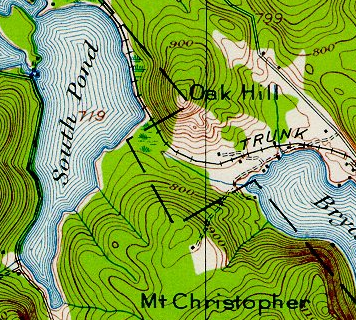
Lot thirteen in the fifth range of Raymond's Grant was purchased by Samuel Bryant Jr. of Greenwood on August 6, 1828.19 To modern eyes this lot is well situated, with frontage on both South Pond and Lake Christopher (Bryant Pond). Samuel and wife Rebecca Stevens would raise a large family here, close to Woodstock town line. Their farm lay within the school district that encompassed what are now Rowe Hill and Greenwood Center (Shadagee), but had no easy access to those neighborhoods.20 In 1834 a road was laid out for the convenience of the Bryants and their few neighbors to what is now the Rowe Hill Road, striking it near Cyprian Cole's place (now the Dunham farm).21 This was a rugged road over the shoulder of Mount Christopher, and where it crossed Cole's land it was to be just a bridle path. It must have proved unpopular, as it was discontinued by the town in 1841. Then as now, the Bryants' land was more easily reached from Woodstock, by the road now called Lakeside Drive.
Locke's Mills and the settlement that would become Bryant's Pond in Woodstock lay just a few miles apart, but there was no direct route between the two until the construction of a bridge across the outlet of North Pond, connecting the "Island farm" (inhabited by John Estes and family after 1848) to the road from Hamlin's Gore to Locke's Mills. The causeway and bridge were completed by March 3, 1845, when a new road was accepted by the town, running from Woodstock into Greenwood across land of Samuel Bryant and Samuel B. Locke, then passing back into Woodstock before re-entering Greenwood and crossing what would come to be known as Johnny's Bridge.22
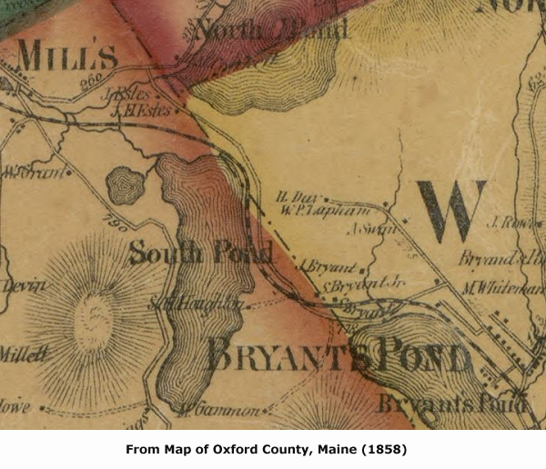
The location of Oak Hill just north of the Bryant homestead required that the new railroad be routed through Samuel and Rebecca's land a few years later. Their formerly quiet farm had become a very busy place. In 1855, though, a new county road was laid out to the east, along the winding course that State Route 26 would follow until straightened in the 1930s.23 The old town road north to Johnny's Bridge was discontinued in 1860, and the Bryants were again isolated.
Samuel Bryant sold pieces of land in 1867 and 1872 while retaining his homestead in the northeasterly part of the lot.24 In 1880 he sold to son Winfield "all and singular the real & personal estate I now own of every name & nature," but he would continue to live on the farm until his death a year later.25. After Winfield's own sudden death in 1887, ownership of the homestead reverted to his mother.26 On April 29, 1889, Rebecca Bryant sold her home of sixty years to John S. Littlefield of Stoneham and his son Horace.27
The Littlefield Petition
John Sewell Littlefield was a Civil War veteran and a farmer, the husband of Anna Barker Russell, and the father of John Clinton Littlefield—long a resident of Greenwood. Clint Littlefield's parents would be residents of Greenwood for less than four years before moving to Woodstock and taking their land with them.
In January 1893 a petition was presented to the Legislature, signed by John S. Littlefield, Horace E. Littlefield, Albert Mountfort and Ernest R. Freeman.28 The last two signers — residents of Woodstock and Boston, respectively — owned that part of the lot that Samuel Bryant had sold in 1867.
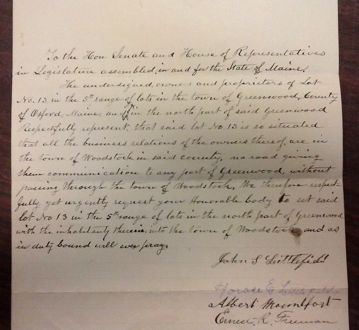
The undersigned, owners and proprietors of Lot No. 13 in the 5th range of lots in the town of Greenwood, County of Oxford, Maine, and lying in the north part of said Greenwood Respectfully represent, that said lot No. 13 is so situated that all the business relations of the owners thereof are in the town of Woodstock in said county, no road giving them communication to any part of Greenwood, without passing through the town of Woodstock. We therefore respectfully yet urgently request your Honorable body to set said lot No 13 in the 5th range of lots in the north part of Greenwood with the inhabitants therein into the town of Woodstock, and as in duty bound will ever pray.
This was accompanied by a second petition, signed by Greenwood's clerk, treasurer and selectmen, along with nine other men from town.
[W]hereas, said owners and proprietors of said lot can be so much better accommodated in every respect if they were in the town of Woodstock, we the municipal officers of Greenwood, and inhabitants and legal voters therein, consent and make no objections, to setting said lot No. 13 in the 5th range of lots in the north part of Greenwood into the town of Woodstock.29
The act of annexation sped through the legislative process, winning final approval on February 17, 1893. After a century of failed attempts, Samuel Titcomb's original plan for Township Number Four had at last been altered.
Greenwood in 1893 was a different town than in 1846, when it had opposed the Watertown petition. Its tax base had broadened with the sale of Phillips Academy's tax-exempt lands, and deepened with the success of the spool mill in Locke's Mills under the management of the Tebbets family.30 Agriculture was still an important part of the town's economy at the close of the century (nearly three-quarters of Greenwood's households in 1900 lived on farms), but spool making had become central to the town's well-being, providing income both to those the mill employed and to those feeding its ravenous appetite for birch. By acceding to the Littlefields' petition, Greenwood showed that it could now afford to lose some arable land and future revenue for the sake of accommodating inconveniently located residents.31 The coming decades would bring rural postal delivery, telephones, automobiles, and cooperative agreements with neighboring towns — all of which would lessen the inconvenience of living in the far-flung corners of town, and reduce the likelihood that Greenwood's boundaries would again be challenged in Augusta.
Notes
1A portion of Number Two was included in a grant made in 1807 to Gorham Academy, later incorporated into Woodstock; and part of Number Three was included in an 1811 grant that would encompass most of the land in Milton and Franklin Plantations. (See Oxford County, Maine (Eastern District) Deeds, book 2, page 514; and book 15, page 4.) Due to this and later adjustments to its lines, Woodstock at present little resembles Titcomb's plan for Number Three. Franklin Plantation was annexed to Peru and Rumford in 1899, but Milton survives as an unorganized township.
2Portland Gazette, April 25, 1814. As we saw earlier, Norway had asked for a similar annexation at the time of its incorporation.
3Columbian Centinel (of Boston, Mass.), Feb. 25, 1815.
4This and related documents will be found in Box 36, Envelope 40, Legislative Records (1825, Graveyard), Maine State Archives.
5Subscribers to this second petition were Merrill Chase, Foxwell Swan, Aron B. Swan, William Frye, Simeon Sanborn, Isaac C. Cross, John Sanborn, Robert Bearce Jr., John Small, Daniel Variel, Enoch Cordwell, Israel B. Fifield, James Walker, Eli Twitchell 3d, Norman Clark, Joseph C. Walker, Francis Barker, Marshall Bonney, Fletcher Russell, Timothy Barker, Ebenezer Greenwood, Oneil W. Robinson, John Oliver, William Estes, Moses Mason Jr., Jacob Elinwood, John Hastings, Robbins Brown, Peter Grover, Jesse Cross and James Grover.
6In 1841 the town voted to see "if the town will Buy a right in the Meetinghouse in this town to Do Business in," and again in 1843 to see "if the town will expend $200 for the privelege of the meeting house." In neither case was action taken. The meetinghouse was a small chapel just above Greenwood City.
7Addison E. Verrill, "Greenwood City in the Forties," Oxford County Advertiser, Aug. 7, 1914.
8Osgood N. Bradbury, Norway in the Forties (1986), p. 21, citing Oxford County Advertiser, Feb. 18, 1887.
9Oxford Democrat, Aug. 13, 1869.
10This and the remonstrance following from Box 177, Envelope 26, Legislative Records (1846, Graveyard), Maine State Archives.
11William B. Lapham, The History of Woodstock, Maine (1882), p. 64.
12"State Valuation of 1845," from Documents Printed by Order of the Legislature of the State of Maine During Its Session A.D. 1846, p. 129.
13William B. Lapham, The History of Bethel (1891), p. 122.
14The erection of a town house "Convenient to do town business and for Public worship" had first been propounded in 1834. The town voted in December of that year to build a house "forty by thirty six feet on the ground and twelve feet Posted," and a committee was appointed to receive proposals. Frederick Coburn, Isaac Patch, Daniel Verrill, Noah Tobey and Richard Hayes made up the committee, which seems to have come to nothing.
15The Norway town house was built in 1838 at Norway Center. It was in a dilapidated condition in 1886, "used as a cider mill, if used at all" according to Bradbury. Norway voted to expend money for a new town house in 1877.
16Oxford County, Maine (Eastern District) Deeds, book 130, page 87.
17Osgood N. Bradbury, Norway in the Forties (1986), p. 21, citing Oxford County Advertiser, Feb. 18, 1887.
18"Isaac Wentworths Road" is now officially known as Ames Lane, but is known to many as the road to the Greenwood Ice Caves.
19Oxford County, Maine (Eastern District) Deeds, book 190, page 251.
20Samuel Bryant Jr. was set off from this school district in 1834, and five years later his neighbor Daniel Cummings was also allowed to spend his school money across the town line in Woodstock. In 1861 — after a town road linking the region to Locke's Mills was discontinued — the Bryants' estate and the adjacent farm "recently occupied by Daniel Cummings" were again set off to the Bryant's Pond school district.
21Samuel and Rebecca's neighbors in the early 1830s were all members of the extended Bryant family. Daniel Cummings, to the west, was Samuel's cousin, and had married Samuel's sister Lydia Ann. South of the Cummings farm lived Melvin Pool, whose wife was Samuel's aunt Abigail Bryant. East of them resided Thomas R. Carman, who had married Sally Bryant, Samuel's cousin, and south of the Carmans lived Sally's parents, Solomon and Sarah (Swan) Bryant. Samuel's neighbor to the east, just across the town line in Woodstock, was his brother Joseph.
22They were probably completed by Sept. 23, 1844, when the new road was laid out. This was called the "Estes Bridge" in one or two early records, but has borne the given name of Mr. Estes for most of its history.
23Oxford County (Eastern District) Registry of Deeds, Records of the County Commissioners, volume 4, page 357. A road similar to this had been proposed in 1836 and 1837, but the requests were denied (ibid., volume 2, pages 226 and 264).
24Oxford County, Maine (Eastern District) Deeds, book 150, page 278; and book 170, page 360.
26Ibid., book 213, page 471; book 211, page 561; and book 188, page 161.
28Both petitions from Box 703, Envelope 9, Legislative Records (1893, Ch. 81), Maine State Archives. One landowner's name was missing from the Littlefields' petition: that of the very recently deceased Alanson Mellen Whitman of Woodstock, whose estate was in the hands of the probate court in Paris even as the petition was read in the House and Senate chambers.
29Subscribers to this second petition were Charles S. Carter, R. D. Rand and John C. F. Roberts, selectmen; A. C. Libby, clerk; W. B. Rand, treasurer; Emons Verrill, O. P. Farrington, E. L. Tebbets, D. M. Goss, A. H. Herrick, Joseph Cummings, Ransom Cole, S. S. Felt and Horace Gerry.
30John G. Tebbets of Lisbon, with partners John F. Dearborn and Emerson P. Brownell, had commenced making spools in Locke's Mills in the late 1860s. After a fire in 1879, Tebbets rebuilt the factory and resumed production under the name "Tebbets Manufacturing Company." His son, Eugene Lester Tebbets, settled in Locke's Mills in 1882 and took over operation of the mill, which suffered a second devastating fire in 1891. The mill property was sold soon after to an out-of-state syndicate, and the factory quickly rebuilt. After a year of mismanagement, E. L. Tebbets again took charge of the operation in 1892. The E. L. Tebbets Spool Company became a subsidiary of the Ekco Products Company of Chicago in 1945.
31Had the town fathers foreseen the value placed on waterfront property by future generations, they might have reconsidered their decision. The assessed value of the Samuel Bryant lot — for which he paid $150 in 1828 — is now approaching $1 million.